
LIDAR
is short for "Light Detection and Ranging". In its simplest form; It
is a remote sensing technology that uses laser beams to measure the distance
between objects and measuring instruments. Since it works at the speed of
light, it can measure the area it measures very quickly and with high accuracy.
In this way, it is used intensively both in the creation of topographic maps
and in other technological studies. We will come to this subject later; But
first, let's take a brief look at the history of physics that made this
technology possible.
In
the early 20th century, Albert Einstein and Max Planck uncovered the fact that
light propagates not only in waves, but also in particles
("photons"). In this way, we were able to better understand the
nature of light, as well as lay the foundations of quantum theory. But
ultimately, such an extraordinary development in basic sciences not only
contributes to our understanding of the universe and nature we live in, but
also provides great opportunities for the discovery of other brand new
technologies.
Accordingly,
thanks to this groundbreaking scientific development in the following years, a
German physicist named Theodore Maiman discovered laser radiation for the first
time in 1960, thanks to an optical assembly he created using photons.
The
discovery of laser beams was also of great importance to LIDAR, because LIDAR
worked directly using laser beams. After the discovery of the laser, a year
later, the first LIDAR sample appeared. Developed by an aviation company named
Hughes Aircraft Company, this new measurement technology would be used in many
branches of science and in much newer technologies. However, it did not see the
expected value in the first years, but when we came to the 1980s, we would have
seen that its use had diversified and became more popular.
How Does
LIDAR Technology Work?
LIDAR
actually has a very simple working principle. While doing this, unlike RADAR
("Radio Detection and Ranging") technology, it uses laser beams
instead of radio waves, so it needs to work continuously, not stationary. Because
unlike radio waves propagating in all directions, laser beams propagate in a
single line. Therefore, either attached to an airplane or a car, it constantly
scans its surroundings and sends laser beams, sometimes as many as 150,000 per
second, creating a "point cloud" of almost hundreds of millions of
dots.
Example of LIDAR Point Cloud Creating the Elevation Model of Trees and Buildings
GreenValley
International
In order
to create this point cloud, it only needs some information to find out the
distance of an object on another planet such as Earth or Mars to the LIDAR
instrument: The return time of the laser beams sent to the object to the
detector. Because the speed of laser beams is already known - which is the
speed of light and is always constant. In addition, when we add the time
information, we can obtain the distance information. Because as we know, in
order to obtain the distance (x); We multiply the velocity (v) by the time (t)
(x=vtx= vtx=vt).
However,
it is worth noting that the return time we mentioned is also used as flight
time. This is because the vehicle the LIDAR device is attached to is generally
a glider or drone, and thus the measurement is done while in motion. Therefore,
instead of the return time of the rays, the time taken until the return of the
beam, that is, the "flight time" is often used in calculations.
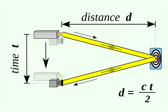
laser beams;
It interacts "twice" because it hits the object once and returns to
the sensor once again. Since we only want to find the distance to the object,
we divide this result by two after multiplying the speed of light by the flight
time of the vehicle. And finally, we come across a formula like this:
Distance of Measured Object = (Speed of Light x Time
of Flight) / 2
The name
of the data obtained by LIDAR from these measurements is "numerical height
information". We will understand that it does not calculate the position
of the object it is measuring, it only calculates the height information, that
is, the "z" coordinate information. In order to detect other
coordinates, we also use GPS together with LIDAR, and thus we obtain the
"x" and "y" coordinate information.
What
should be noted here is that the measuring vehicle (for example, the plane)
wobbles in the face of unpredictable weather conditions, apart from being
underway. As might be expected, even the slightest wobble and change of
direction will cause errors in the measurement. Therefore, we try to overcome
this negative situation with a device called the inertial (inertial)
measurement unit (IMU) that measures these deviations using tools such as gyroscope
and magnetometer.
Advantages
and Disadvantages of LIDAR Technology
Of course,
LIDAR is not alone among remote sensors. The more famous and frequently used
RADAR technology, as we have just mentioned, uses radio waves as opposed to
laser beams. These technologies, which work by taking advantage of the
existence of these two phenomena, have some advantages and weaknesses against
each other.
The first of the advantages of LIDAR technology compared to RADAR is that the digital models created by the laser beams have a short wavelength, so they have a higher resolution and therefore become a much better choice for detecting small objects. Another important advantage is that it can create a full 3D image of an object, thanks to its strong sensitivity. As we will understand, LIDAR can give results with much higher accuracy compared to RADAR in short range remote sensing and photogrammetry studies.
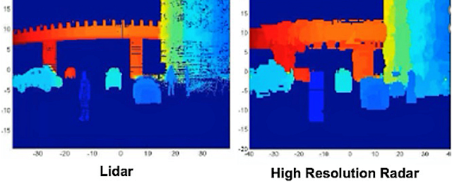
Resolution
Difference Between LIDAR and RADAR FierceElectronics
However,
LIDAR technology also has some disadvantages. For example, LIDAR technology is
quite expensive compared to RADAR. In fact, we can say that this is the most
important disadvantage of LIDAR. Another negative feature is that the
technology it uses has a much more limited use at night or in bad weather
conditions compared to RADAR. Finally, laser beams can reach shorter distances
than radio waves, although they can obtain higher resolution data compared to
RADAR technology. In this respect, we can say that RADAR technology is more
useful in large-scale studies and uses (for example, in shipping).
Areas of
Use of LIDAR Technology
LIDAR is
not as popular as RADAR today. However, if we look at the number of areas used
by LIDAR technology, it provides great services to about 50 different areas.
Agriculture
By
obtaining high-accuracy, numerical elevation information of agricultural areas,
it allows us to learn which areas have more slope or which direction facing
areas get more sun. Thus, we can classify agricultural lands by looking at
their production value and use them more efficiently. So much so that we can
determine very accurately which areas will have priority not only for planting,
but also for fertilization.
Forestry
It is a
technology frequently used in the planning and management of forest areas. For
example, it allows us to determine the biomass volume and number of trees in a
forest. In addition, it helps us to determine which silvicultural processes
should be processed in forest areas or which areas are in degraded forest status.
Apart from these, perhaps more importantly, it can show which routes we can use
in case of fire when making plans to fight forest fires.
Air
pollution
Because
laser beams can capture objects equal to or larger than their wavelength, we
can use LIDAR technology to detect the extent and change of air pollution,
especially in highly populated urban areas. For example, we can learn about the
presence of pollutants such as carbon dioxide, sulfur dioxide and methane in
the air and how much they are.
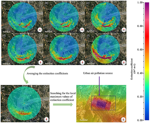
A Sample Air Pollution Map Using LIDAR
Urban air pollution monitoring using
scanning Lidar
Flood and
Flow Models
Since
LIDAR is able to obtain high resolution digital elevation information, we can
learn the current state of the river and its future expansion capacity in the
process of modeling bridges over river beds. Apart from these, it makes great
contributions to the preparation of disaster planning, in the determination of
water flow lines and analysis such as estimation or progression direction, by
being able to create slope and topography maps of any region.
Building Modeling
Again, since it can make 3D models in high resolution,
the desired data can be obtained by making low altitude flights over the
building to be modeled.
Transport
It is
currently used to determine the condition of roads and their surroundings. In
addition, while preparing new road plans; It helps us to determine the route,
how many lanes it will have, how much excavation and filling will be done in
which area, how much the slope will be, and finally the quality standard.
Autonomous
Vehicles and Smartphones
It
determines the distance of autonomous vehicles to the surrounding buildings,
cars or living things up to 200 meters, ensuring that the vehicle can travel
safely. That is, it functions as a kind of eye of the vehicle. So much so that
it can detect even a few centimeters of detail from 100 meters away! However,
as we mentioned in the disadvantages section, it is a matter of debate whether
it should be used or not due to its high cost.

Simulated Image of an Autonomous Vehicle with LIDAR Remote Sensor Velodyne Lidar
The
situation is different with smartphones. LIDAR remote sensors, which have
recently been used in the iPhone 12 Pro smartphone model, provide the
opportunity to make instant changes on the created model by producing a 3D
model of the area within 5 meters, mostly for design purposes. In addition, it
makes it possible to play games directly in environments such as home through
the augmented reality theme in the game industry - which is the opposite of VR
(Virtual Reality) technology, that is, it integrates games into the real world
rather than increasing the reality in the game's own world.
Robotics
Very
similar to its use in autonomous vehicles, it works like an eye of the robot it
is in, and thanks to its high speed operation, it allows robots to interact
with their environment instantly - both this aspect and the ability to obtain
high-resolution data make it very useful for studies in the field of robotics.
occupies an important place.
Conclusion
As
you can see, LIDAR technology emerges as a very important technology when
high-accuracy and high-resolution analyzes are required. Although it cannot
sometimes replace RADAR due to its cost and limited number of limitations, we
can take our technology further by making use of the power of light, and this
contributes greatly to our efforts to make our Earth a more livable place.
Comments
Post a Comment